Cyclones
Cyclones - Cyclones are swirling system of clouds and winds around a low pressure zone.
Cyclones are violent winds that move in circle. They rotate in counter clockwise in Northern hemisphere and clockwise in Southern Hemisphere.
Types of Cyclones
- Temperate Cyclone
- Tropical Cyclone
Temperate Cyclone
Temperate Cyclone - These are the low pressure system which are generally associated with cold front, warm front and occluded front. It is also known as Mid-latitude cyclone or Extra tropical cyclone.
Different stages in the formation of Temperate Cyclone
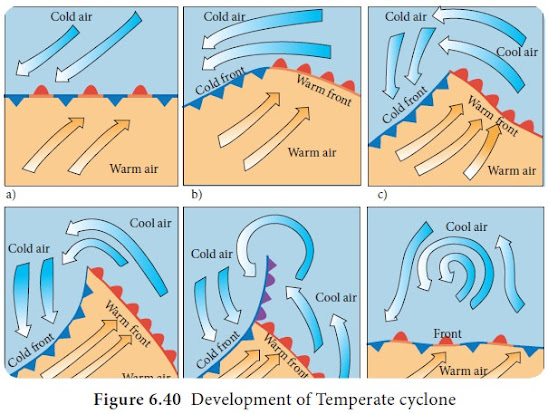
- Convergence of two air masses with different characteristics where the air masses move parallel to each other and a stationary front is formed.
- The warm and cold air masses penetrate into the territory of each other forming a wave like front.
- It is the mature stage with warm and cold fronts starting to move towards each other and warm sector wedged between the cold sectors.
- The warm sector is narrowed in extent due to the advance of cold fronts and the warm air glides over.
- The occlusion starts with warm air rising completely over the cold air. Cold front completely overtake the warm front.
- The warm sector completely disappears and the occluded front is eliminated with the cyclone dying, i.e., frontolysis.
The role of Jet Stream in the formation of Temperate Cyclone
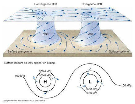
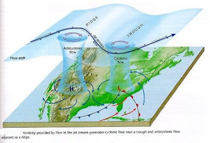
- The jet stream being quasi-horizontal in nature which results in upper divergence in some location and convergence in some.
- The upper divergence allows the surface convergence which helps in bringing together the warm and cold air masses and subsequent formation of fronts.
Tropical Cyclone
Tropical cyclone - It is a system of low pressure with very high wind speed along with a large system of clouds causing heavy rainfall. It usually developed within the tropics, over the ocean then it moved towards the land.
In other words, Tropical cyclones are the low pressure high velocity wind system originating within the tropics over the ocean.
Classification used in India for Tropical Cyclone
- Low Pressure Area - Wind Speed (less than 31 kmph)
- Depression - Wind Speed (31 to 49 kmph)
- Deep Depression - Wind Speed (50 to 61 kmph)
- Cyclonic Storm - Wind Speed (62 to 88 kmph)
- Severe Cyclonic Storm - Wind Speed ( 89 to 118 kmph)
- Very Severe Cyclonic Storm - Wind Speed (119 to 221 kmph)
- Super Cyclone - Wind Speed (more than 221 kmph)
Different stages in the formation of tropical cyclone
Low pressure area → Depression → Deep Depression → Cyclonic Storm → Severe Cyclonic Storm → Very Severe Cyclonic Storm → Super Cyclone
Tropical Cyclones are named differently in different parts of the world. For example -
- Indian Ocean - Cyclone
- Atlantic Ocean - Hurricane
- South China Sea - Typhoon
- Near Japan - Taifu
- Near Philippines - Bagui
- Northern part of Australia - Willy Willy
(Conditions required for the formation of Cyclones
1. Temperature
- Temperature (27℃ or more upto the depth of 60-70 m) → Faster Evaporation & Strong Convection → Formation of huge cumulonimbus clouds.
- Coriolis force → Deflects the winds
4. Minimum vertical wind shear
- (Wind Shear is the difference in air speed at different levels)
- More wind shear → Washed away humidity level (that's why restricts the formation of cyclone)
- Less wind shear → Calm condition → facilitate the formation of cyclone
- Example - There is less formation of cyclones in Arabian Sea because of strong wind shear than Bay of Bengal.
6. Upper Atmospheric divergence
- Upper Atmospheric divergence → Suction of air at the surface → Stronger convection
7. Any kind of pre-existing disturbance like depression)
Once formed, Tropical cyclone moves from east to west because they are in the belt of tropical Easterlies (Trade winds).
Whereas Temperate cyclone moves from west to east because they are in the Westerlies.
Once, cyclone hits the land, it dissipates as the conditions changed on the land with respect to the sea (low humidity, no such strong convection, etc.)
- At Equator - Surrounding air fills the gap from all the direction without deflection in wind as Coriolis force is zero (low pressure formed) → no formation of cyclones at the Equator
- In Northern Hemisphere - Winds deflect towards right due to Coriolis force → Cyclone formed (moving in Anti-clockwise direction)
- In Southern Hemisphere - Winds deflect towards left due to Coriolis force → Cyclone formed (moving in Clockwise direction)
Conditions required for the formation of cyclone -
- Temperature above 27℃ to ensure sufficient evaporation.
- Depth of warm water should extend for upto the minimum of 60 to 70 m.
- High humidity level of 50 to 60%.
- Minimum vertical wind shear, so that the humidity and warm air is not swept away.
- Coriolis force causing the wind deflection and cyclonic circulations. This limits the latitudinal extend of Tropical cyclone to 5° to 25° N/S (less than 5° N/S - not much Coriolis force is available to deflect the wind & more than 25° N/S - temperature above 27°C is not achieved).
- Divergence in upper troposphere causing convergence near to the surface.
- Pre-existing low level disturbance which gradually gets accentuated to depressions and then to cyclonic storms.
Structure of Tropical Cyclone
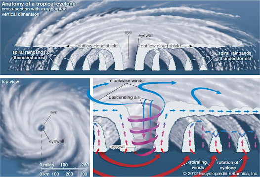
1. Eye of the Cyclone
- It is the centre of the storm.
- It is usually, 5-50 km of diameter with clear sky, lowest pressure and highest temperature.
- The air from above sinks into the eye
- All cyclones did not form an eye. Cyclones which have winds descending at the centre form eye.
2. Eye wall
- It is the wall of thick cumulonimbus cloud with 10-20 km of width.
- It has the strongest wind in the cyclone.
- Thunderstorm occurs in this region due to intense convection and rainfall.
3. Spiral bands
- These are the system of clouds which extend upto 200 km.
- They are also known as rain band or feeder bands extending for 100s of km leading to galaxy like appearance.
4. Annular zones
- These are the zones of suppressed cloudiness with low precipitation, low humidity and descending air.
5. Outer convective bands
- These are the system of lesser cloud with instability and convection at the edge of the main cloud mass.
6. Landfall
Naming system of cyclones
- In 2004, 8 countries of Indian ocean agreed to have a common naming system of cyclones in Indian ocean.
- Each of the countries submitted a set of 8 names which are arranged in alphabetical order to form a matrix.
- The suggested name should be neutral politically, culturally, religiously as well as gender neutral and should be easy to pronounce.
- If any country raises objection, that name should be removed from the list.
- WMO maintains the list of names arranged in sequential order and assigns the name alternatively.
- These names are announced by the regional specialised meteorological centre of New Delhi.
- The earlier matrix of name got expired in 2019 and a new system of names with 13 countries were introduced in September 2019.
- 13 Countries were -
- Bangladesh
- India
- Maldives
- Myanmar
- Oman
- Pakistan
- Srilanka
- Thailand
- Iran
- Qatar
- Saudi Arabia
- UAE
- Yamen
Last 5 countries were added in September 2019.
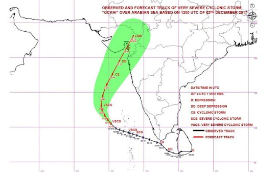
Re-curvature of cyclone - When the air currents in the local atmosphere push the cold air from the poles towards the equator and interfere with the cyclone formation, the cyclone which is about to diminish gets more winds and comes under the influence of westerlies which causes a deflection towards right or eastward which is known as re-curvature of the cyclone.
It is a very difficult phenomena to predict.
Example - Cyclone Ockhi of 2008
Q. Why there is more formation of cyclones in Bay of Bengal as compared to Arabian sea?
There is more formation of cyclones in Bay of Bengal as compared to that in Arabian sea because of -
- More fresh water supply in Bay of Bengal (Fresh Water evaporates faster than Saline water)
- Wind speed over Arabian sea is higher which swept away the humidity whereas there is bit calm condition over the Bay of Bengal.
Difference between Tropical and Temperate Cyclones -
Tropical Cyclone
- Produced mainly over sea
- Generally originate in Tropical region (between 8 to 20° N/S)
- Limited to a small area
- Travel from east to west (because of the influence of easterlies)
- They are forecasted by high temperature and humidity but still/calm air.
- They are associated with violent winds with great speed, dense cloud and heavy rains.
- They are largely a summer phenomena.
- They are generally caused due to strong convection over the sea.
Temperate Cyclone
- Produced both on land as well as over sea.
- Originate in mid-latitudinal regions (between 35-65° N/S)
- Occupy areas measuring 1000s of km
- Travel from west to east (because of the influence of westerlies)
- Forecasted by fall in temperature and pressure, wind shifts and a halo around the sun and the moon.
- Wind speed is low and the rainfall is light which continues for many days.
- They are most intense in winter.
- They are generally caused when two air masses meets.
Polar Vortex
- Polar vortex is a large air of low pressure and cold air surrounding the Earth's pole.
- The term vortex refers to the counter clockwise flow of air which keep the cold polar air locked inside.
- The polar winter night jet stream keeps this region covered with strong wind.
- Occasionally, when the vortex weakens it expands and sends the cold air southwards along with jet stream. This brings down the temperature in southern region of polar vortex to the coldest level of below freezing point.
- Example - Due to weakening of polar vortex, USA sometimes faces freezing cold climate.
- Polar vortex is not present in South pole because of the presence of large landmass (Antarctica) and thus have a strong jet stream whereas in North pole, Arctic is not a single land mass. It consists of land as well as water. That's why in summer because of the melting of ice, polar vortex weakens.
PYQ
In South-Atlantic and South-Eastern Pacific regions in tropical latitudes, cyclones does not originate. What is the reason?
- Sea surface temperature is low.
- Inter-tropical convergence zone seldom occurs.
- Coriolis force is too weak.
- Absence of land in those regions.
Answer - 2
- ITCZ - Provides calm condition which is suitable for cyclone formation.
- ITCZ does not occurs over there. Also trade winds are strong there which swept away the humidity.
Previous Article - Air Mass
Next Article - World's Climatic Regions
Notes on other subjects
Optional Notes
Note - This is my Vision IAS Notes (Vision IAS Class Notes) and Ashutosh Pandey Sir's Public Administration Class notes. I've also added some of the information on my own.
Hope! It will help you to achieve your dream of getting selected in Civil Services Examination 👍

10.png)
.jpg)


0 Comments